Manaslu Tsum Valley Trekking Itinerary- 17 nights/18 days.
Manaslu Circuit with Tsum Valley trek in the off-beaten path of northwestern Nepal witnesses remote village lifestyle while circling the eighth highest mountain of the world. The 18 days long trek traverses to the beautiful Annapurna and Manaslu region to explore the rich wilderness and hidden valleys.
Manaslu Circuit with Tsum Valley trek begins west of Kathmandu at Soti Khola towards Macha Khola then to Jagat before entering Tsum Valley. The trek explores the villages of Lokpa, Chumling, Chhokang Paro, Nile, Mu Gompa, and Bursi in the restricted valley. From there, the trek takes on the Manaslu circuit trail in the Budhi Gandaki River valley. Passing from Sama and Samdo village, the trek’s challenging high pass Larkya La crosses from where the trek returns to Tal.
The trek is lengthy and requires you to walk on rugged terrains with high passes reaching over 5,000m/16,404ft. Moreover, the trail is secluded in the remote area, and the tea houses and settlements are very distant and scattered. Hence, it is suited to trekkers who have had past trekking experiences.
The Tsum Valley is one of the most secluded valleys in Nepal. Situated in the Manaslu Himalaya Trekking Region, high up near the Tibetan border, the whole area has a definite Tibetan Buddhist feel to it and is quite different from the surrounding countryside.
A restricted area until 2008, Tsum Valley is relatively un-trekked by hikers, yet the starting point is only 7 hours drive from Kathmandu.
Most of the 14 days are trekked at altitudes over 3,000m. With the altitude and with walking days stretching from 5 to 7 hours, a fairly good level of fitness is required for this trek.
The trail passes through pine forests, along raging rivers with cascading waterfalls and incredible suspension bridges, through fascinating villages and to several gompas, monasteries, mani walls, and stupas, not to mention Milarepa’s Cave.
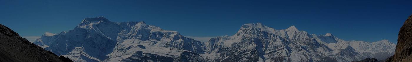
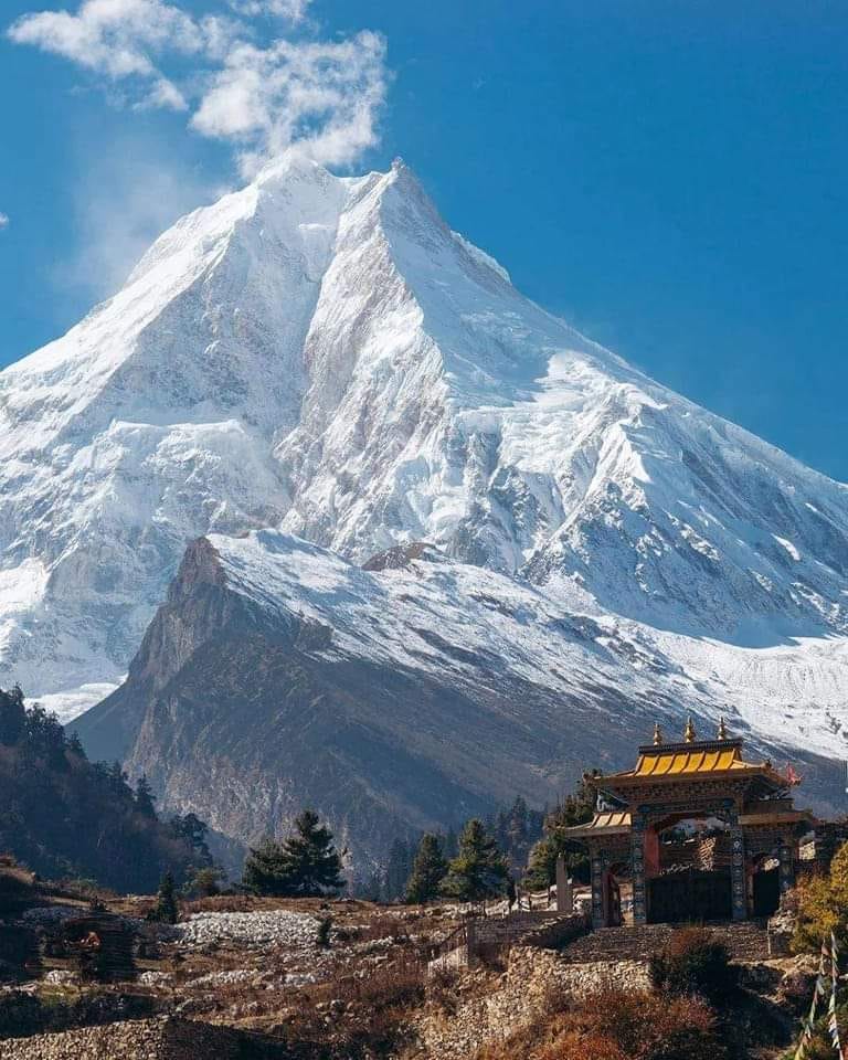
On display are the mountain ranges of Himalchuli (7,893m), Ganesh Himal (7,140m), Manaslu (8,163m), Churke Himal and the Poshyop Glacier.
For trekkers who are fascinated
Trip Highlights
-
Visit the less crowded, untouched, and restricted villages of Lokpa, Chumling, Chhokang Paro, and the Nile in Tsum valley
-
Closeup views of the world’s eighth highest peak, Manaslu, along with adjoining Annapurna Massif, Langtang Himal
-
Trek to three of the fascinating trails of Tsum valley, Manaslu circuit and Annapurna circuit
-
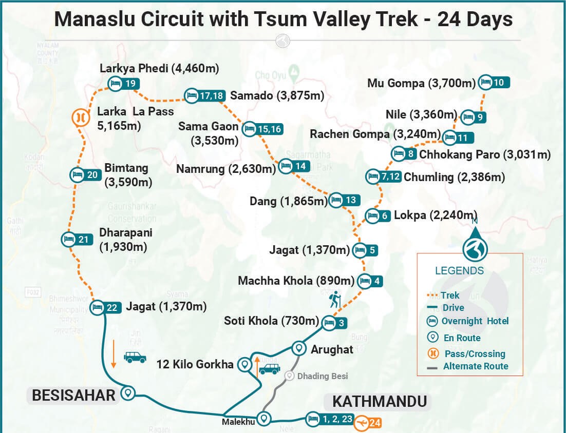
Cross the challenging and highest point of the trek Larkya La Pass (5,160m)
-
Intermingle with the Gurung and Sherpa communities living in the Tibet and Nepal border
-
Insight into the Tibetan Buddhist culture and traditions via the mani walls, Milerapa cave, Rachen Gompa, and Mu Gompa
-
Chance to witness the rare wildlife including Thar, Himalayan Monal, Snow leopard, in the Budhi Gandaki and Marsyangdi river valley
Day 1.
Drive from Kathmandu via Arughat to Soti Khola (730m / 2896ft)
(160km / 99.4miles) 7 hrs
After an early breakfast, we will start our trip with a drive along the Prithivi Highway west of Kathmandu. The scenic ride lets you enjoy the views of terrace farms, raging rivers, beautiful villages, and dense forests.
You will be crossing the Trishuli River to Dhading Bensi and continue to Arughat, driving along with the scenic villages while continuously following Dorandi Khola northwards to Gorkha. From the road, you get stunning views of Manaslu and Ganesh Himal. Our destination, however, is still two hours drive away from Arughat to Soti Khola.
Overnight stay at Hotel
Included meals (Breakfast + Lunch + Dinner)
Day 2
Trek from Soti Khola (730m /2896ft) to Machha Khola (890m / 2,965ft)
Itinerary Facts
Trek Distance
9.7km /6miles
Highest Altitude
890m / 2,965ft
Trek Duration
6 to 7 hrs.
We continue to follow the low valley to the north, observing the majestic Himalayan peaks from time to time as we hike up the picturesque densely forested Buddhi Gandaki Valley. The route passes through several small villages until the valley widens. From the opposite side of the valley, you will see a large stream flowing into the Budhi Gandaki River. As we continue our journey, we reach the beautiful village of Lapubesi (880m). From Lapubesi, we descend to a meandering path to reach Macha Khola.
Overnight stay at Hotel
Included meals (Breakfast + Lunch + Dinner)
Day 3
Trek from Machha Khola (890m / 2,965ft) to Jagat (1400m / 4,593ft)
Itinerary Facts
Trek Distance
22km / 13.7miles
Highest Altitude
1,400m / 4,593ft
Trek Duration
6 -7 hrs.
We cross the Tharo Khola river and head upstream to Khola Beni. The route takes your forward alongside dramatic gorges with waterfall sculptured rocks and some landslides. After crossing a bridge, we reach a tiny village of Kholabesi and then natural hot springs at Tatopani (Tatopani means hot water in Nepali).
From the hot springs, we catch another trial and cross the Budhi Gandaki River on a suspension bridge. We will then walk past a landslide and reach Dobhan village. From Doban, we cross a suspension bridge over the Yaru Khola and climb stone stairs to Thado Bharyang before ascending to the charming village of Jagat. Jagat is the entry point of Manaslu Conservation Area, and we will register our permits at a police checkpoint in Jagat.
Overnight stay at a lodge.
Included meals (Breakfast + Lunch + Dinner)
Day 4
Trek from Jagat (1,400m / 4,593ft) to Lokpa (2,040m / 4,493ft )
Itinerary Facts
Trek Distance
17.5km / 10.8miles
Highest Altitude
2,040m / 4,493ft
Trek Duration
6 to 7 hrs
We make an entry into the restricted region of Manaslu by climbing over a ridge to Salleri. We walk along the riverbanks then cross the Budhi Gandaki River on a long suspension bridge. As we continue to walk, the valley widens towards Philim. As we pass Ekle Bhatti, the trail separates one takes you to Tsum and the other Manaslu.
We hike up towards Lokpa across several villages. Rivers become narrower, and we can see the confluence of Syar Rivers from Tsum valley. We trek on the right side of Tsum valley to reach Lokpa village, the first village in Tsum valley that provides clear views of the Manaslu range. In fact, it’s a completely hidden valley blessed by Padmashamva centuries ago. (Padmashamva is one of the founding fathers of Tibetan Buddhism.) You will get stunning views of Himalchuli, and Boudha Himal from Lokpa village.
Overnight stay at Lokpa
Included meals (Breakfast + Lunch + Dinner)
Day 5
Lokpa (2,040m / 4,493ft) to Chumling (2,386m / 6,692ft)
Itinerary Facts
Trek Distance
6.3km / 3.9miles
Highest Altitude
2,386m / 6,692ft
Trek Duration
4 to 5 hrs
After breakfast, we start walking from Lokpa Village- a wild route entrance to Tsum valley. On a clear day, you can get stunning views of Baudha Himal (6672m) and Ganesh Himal VI from the routes joining Lokpa to Chumling.
Our trail first descends to Lungwa river valley, then climbs up through a subtropical forest of dense rhododendron and pine. There are no villages between Lokpa to Chumling. We will be crossing Syar Khola to arrive at the village of Chumling. A side trip to the upper parts of Chumling takes you to a monastery from where you can catch great views of Ganesh Himal. Chumling has a health post and three monasteries - Panago Gumba, Mani Dhungyur, and Gurwa Gumba.
Overnight stay at Chumling.
Included meals (Breakfast + Lunch + Dinner)
Day 6
Trek from Chumling (2,386m / 6,692ft) to Chhokangparo (3,010m / 9,875ft)
Itinerary Facts
Trek Distance
8.4km / 5.2miles
Highest Altitude
8.4km / 5.2miles
Trek Duration
5-6 hrs
Today, we enter the upper valley, a part of the inner Himalayas. The trail continues along the Syar River down to Domje - the largest city in Tsum valley. From Domje, we continue climbing uphill to arrive at Chhokangparo. On a clear day, we can get magnificent views of Himalchuli and Ganesh Himal from Chhokangparo. At Chhokangparo, you will also have the opportunity to experience the hospitality of local (Tibetan group “Tsombo”) people along with Tibetan Chiya (butter tea) and local meals.
Overnight stay at Chhokang Paro
Included meals (Breakfast + Lunch + Dinner)
Day 7
Trek from Chhokangparo (3,010m / 9,875ft) to Nile (3,361m / 11,026ft) via Milarepa Piren Phu Cave
Itinerary Facts
Trek Distance
9.7km / 6miles
Highest Altitude
3361m / 11,026ft
Trek Duration
4 -5 hrs
We walk a relatively shorter distance today. The Nile, on the western side of the Shikhar Khola, is about a 20-minute walk across from Chhule, which is the last village in the north upper Tsum Valley. When you reach Ngakyu Leru, you will notice people farming as the land is fertile.
After passing Lamagaon, you will reach St. Milarepa Piren Phu Cave, where his footprint is said to be preserved in rock. Piren Phu (pigeon cave) is one of the most sacred caves in the Tsum valley. There are two separate Gumbas attached to the rocky cave. Richly painted Buddhist murals, excellent artistic scripts carved on stones, long prayer flags, and significant Buddhist paper scripts make Piren Phu Cave one of the most important socio-cultural assets in the valley. Then, we cross a suspension bridge over the Shiar River and continue our trek through several villages to arrive at Nile.
Overnight stay at Nile
Included meals (Breakfast + Lunch + Dinner)
Day 8
Trek from Nile (3,361m / 9,875ft) to Mu Gompa (3,700m / 11,026 ft)
Itinerary Facts
Trek Distance
7.9km / 4.9miles
Highest Altitude
3,700m / 11,026ft.
Trek Duration
3 - 4 hrs
A short walk from the Nile along the west bank of the valley close to the Tibetan border leads to Mu Gompa - the highest point of the Tsum Valley Trek. We hike up through yak pastures through typical dry and arid trans Himalayan terrain. The Mu Gompa monastery has rows of Chortens and provides beautiful mountain views. Moreover, you get an opportunity to visit Dhephu Doma Gompa - one of the oldest monasteries in the Tsum.
Overnight stay Mu Gompa
Included meals (Breakfast + Lunch + Dinner)
Day 9
Mu Gompa (3,240m/ 10,629ft) to Chhokangparo (3,010m / 9,903ft)
Itinerary Facts
Highest Altitude
3,240m / 10,629ft
Trek Duration
6 hrs.
From Gompa, the descent begins. We descend to Rachen Gompa, then Chhule and reach Phurbe. Rachen Gompa lies in the border area of Nepal and Tibet, and it sits surrounded by humongous mountains. But the destination for this day takes you through a forested area and finally at Chhokangparo.
Overnight stay at Chhokangparo
Included meals (Breakfast + Lunch + Dinner)
Day 10
Trek from Chhokangparo (3,010m / 9,903ft) to Chumling (2,386m / 7,827ft)
Itinerary Facts
Highest Altitude
3,010m / 9,903ft
Trek Duration
6-7hrs
Our descent from Chhokung Paro continues as we reach Gho. You will be crossing a suspension bridge near Gho and hiking forward to reach Rainjam Village. We leave Rainjam village, descend to Tsum Valley and finally reach Chumling - our destination for the day.
Overnight stay at Chumling
Included meals (Breakfast + Lunch + Dinner)
Day 11
Trek from Chumling (2,386m/7,827ft) to Deng (1860m / 6,101ft)
Itinerary Facts
Highest Altitude
2,386m / 7,827ft
Trek Duration
6-7 hrs
Today, you will leave Chumling and continue descending, so today's journey should be an easier one. You will be moving along the bank of Shair Khola to reach Lokpa Village. On a nice day, you may pass through large flocks of sheep and goats along the path.
The trail after Lokpa descends as we cross the Budi Gandaki on a solid bridge then enters a narrow gorge from where it starts to ascend and descend while gradually climbing through the valley. We cross a river on a suspension to Nupri and then pass through bamboo forests to reach the Gurung village of Deng (1860m).
Overnight stay at Deng
Included meals (Breakfast + Lunch + Dinner)
Day 12
Trek from Deng (1860m /6101ft ) to Namrung (2,900m / 9512ft)
Itinerary Facts
Highest Altitude
(2,900m / 9512ft)
Trek Duration
6-7 hrs
From Deng, we climb to Rana (1,910m) Village and hike forward to Bhiphedi (2,130m). The path starts meandering in and out of the valley canyons crossing the Serang Khola before leading us to Ghap (2160m). As we leave Ghap, the valley becomes steeper as we continue a long climb through bamboo and rhododendron forests. After crossing the wild rivers a couple of times, you will reach the Namrung Village - the entry point to the Nupri region. The locals of Namrung Village are Tibetan descendants.
Overnight stay at Namrung
Included meals (Breakfast + Lunch + Dinner)
Day 13
Trek from Namrung (2,900m / 9512ft) to Sama Gaon (3,530m / 11,581ft)
Itinerary Facts
Trek Distance
17.7km / 11miles
Highest Altitude
3,530m / 11,581ft
Trek Duration
8-9 hrs
We leave Namrung and pass through many Mani wall entrance gates, several Buddhist Gompas, and a few villages. Then the valley opens out, and our route passes through Sho Village. This village has many yaks and is known for excellent views of Manaslu (8163m) and Manaslu North (7,157m).
It is a great day to savor the great mountain views. To trek to Sama Gaon (3530m), we follow the right riverbank enjoying the views of Peak 29. A couple of hours of climbing through the forest brings us to Shyala village, from where we can see Phungi, Manaslu, and Himal Chuli mountains. The Shyala villagers rely on yaks, potatoes, and barley to survive this distinctly Alpine region.
As we hike up, you will see Ganesh Himal towards the east and the Himalchuli and Manaslu in the south. Soon enough, as you look down, you will be able to see two rows of houses that form the central part of Sama Gaon. At the far end of Sama Gaon stands the well-known Sama Gaon Monastery. The Tibetan border is very near from here. We stop at Samagaon for a day to acclimatize.
Overnight at Hotel
Included meals (Breakfast + Lunch + Dinner)
Day 14
Trek from Sama Gaon (3,530m / 11,581ft) to Larkya La Phedi (Dharma sala) (4,460m / 14,632ft)
Itinerary Facts
Trek Distance
18.5km / 11.4miles
Highest Altitude
4,460m / 14,632ft.
Trek Duration
5 to 6 hrs
We start early in the morning from Sama Gaon and head to Samdo. Our hike takes us through the terraced fields alongside old mani walls, across the Budhi Gandaki wooden bridge, and gradually up to the Samdo valley. Another mani wall marks the beginning of the ascent to the Larkya La Pass. We cross two streams and witness the Larkya Glacier. Then, we go around the Salka Khola Valley, climb up once again and come to a stone guest house (4,450 m), which is not a lodge but a kind of resting place called Dharmasala, also known as Larkya La Phedi. Today you will enjoy fantastic views of Larkya Glacier and the impressive Manaslu mountain. We rest at Larkya La Phedi and prepare to cross Larkya La Pass the next day.
Overnight stay at Hotel
Included meals (Breakfast + Lunch + Dinner)
Day 15
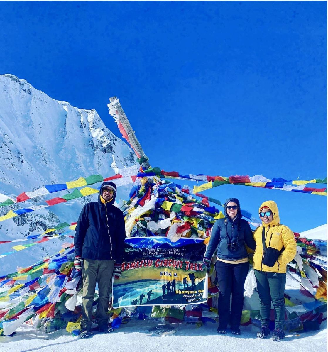
Trek from Dharamsala to Bhimtang (3,720m / 12,205ft) by crossing Larkya la Pass (5,160m / 16,929ft)
Itinerary Facts
Trek Distance
24.7km / 15.3miles
Highest Altitude
5,160m / 16,929ft
Trek Duration
7 - 8 hrs
We leave Dharmasala very early in the morning because we will be hiking along the longest and the toughest section of this trek. We need to cross the Larkya La Pass (5,160m) before the wind starts blowing strongly at the pass. The trail starts as a gentle climb across the moraine. It descends slightly to a lake and then becomes rough and indistinct as it crosses steep grassy slopes. We continue on the moraine to a ridge marked by two cairns. From here, the prayer flags marking the pass are visible.
We descend to the four frozen lakes then make the final steep climb to the pass. The pass opens outstanding panoramic views of Himlung Himal, Cheo Himal, Kanguru, Minjung, and the huge Annapurna II. We savor the spectacular views from the top of the pass. Then the descent begins. The trail follows the top of the moraine to the west and makes a set of steep, rough switchbacks as it crosses the moraine, then descends more gently on loose gravel to another grassy moraine at 4,450m. The trail now becomes easier to follow and reaches a small meadow. The valley becomes broader as the trails head down to a large meadow, past a mani wall and a small rest house that marks Bhimtang at 3,590m.
Overnight at Hotel
Included meals (Breakfast + Lunch + Dinner)
Day 16
Trek from Bhimtang (3,720m / 12,205ft) to Gho (2,550m / 8,367ft)
Itinerary Facts
Trek Distance
10km / 6.2miles
Highest Altitude
(3,720m / 12,205ft)
Trek Duration
4 - 5 hrs.
From Bhimtang, the trail crosses the moraine, descends to the Dudh Khola headwaters, crosses a wooden bridge, then into pine and rhododendron forest to Hompuk (3,430m). The rhododendrons are multi-colored, and the forest is home to sheep, horses, and monkeys. You will also be able to enjoy the panoramic views of Phungi, Manaslu, Manaslu North Peak, Cheo Himal, and Himlung Himal. A 30-minute descent through the forest takes you to Sangore Kharka meadow. You will then cross a landslide before making a steep climb to a ridge decorated with prayer flags. The route ultimately descends to the river bank at Gho (2,575m).
Overnight stay at a lodge
Included meals (Breakfast + Lunch + Dinner)
Day 17
Trek from Gho (2,550m / 8,367ft) to Tal (1,700m / 5,577ft)
Itinerary Facts
Trek Distance
13km / 8miles
Highest Altitude
2,550m / 8,367ft
Trek Duration
4 - 5 hrs
The route is full of ups and downs, mostly through fields but occasionally through dense forests. Less than an hour walk through the fields and intermittent rhododendron and oak woods takes you to Tilije - a multiethnic community. You will exit Tilije through a stone arch, cross the Dudh Khola and follow along its embankment that descends through the scrub forest. As you trek ahead, the walls of the Marsyangdi Valley start to look larger, and finally, the houses of Dharapani appear in the distance. You will then pass Thonje village via a wooden bridge and a chorten-shaped arch, and Dharapani lies across a long suspension bridge over the Marsyangdi. But your trail continues on the sandy banks of the Marsyangdi River until you reach Tal. The prayer flags, mani walls, and chortens in and around Tal tell you that Tal is a Buddhist village.
Overnight stay at a lodge
Included meals (Breakfast + Lunch + Dinner)
Day 18
Drive from Tal (1,700m /5,577ft) to Besisahar then Kathmandu
Itinerary Facts
Driving Hours
9 - 10 hrs
In the morning, we take a local Jeep or bus from Tal to Besisahar. It is an approximately 4 to 5 hrs drive that passes through several villages, the towns of Bhulbhule and Khudi to Beshishar. We need to reach Besisahar before 3 p.m to catch the last jeep or local bus to Kathmandu. On our journey back to Kathmandu, the road follows the scenic Marsyangdi River, then meets the Trishuli River as we head east along the Prithvi Highway. Along the way, you will get good views of the lush scenery, terraced farmland, and perhaps some final glimpses of the tall snow peaks.
Included all standard meals (Breakfast + Lunch)
Total Inclusive Package Price per person: USD 1995
-
1. Transportation from Kathmandu via Arughat to Soti Khola (trek start) by private Jeep and from Tal (trek end) to Besisahar, then back to Kathmandu by private Jeep
-
2. All standard meals (19 Lunches, 18 Dinners, and 19 Breakfasts) during the trek
-
3. Accommodations at best tea houses/ lodges in trek regions (Generally twin sharing rooms) for 18 days.
-
Government licensed English-speaking Discovery guide and porter to carry your luggage. For every two trekkers, we assign a porter. The luggage weight limit per trekker is 10 kg.
-
Guides and porter cost, their meals, insurance, salary, lodging, transportation, and other necessary equipment
-
4. Manaslu & Tsum Valley Special Permits with Conservation Area Permits, and Annapurna Conservation Area Permit (ACAP) fees
-
5. Snacks (cookies) and seasonal fresh fruits every day
-
6. All government, local taxes, and official expenses
-
7. Rescue operation arrangements in case of complicated health conditions
-
8. Souvenir - Company's T-shirt & cap
-
9. Nepal Everest Himalaya Hiking trek achievement certificate
-
10. Farewell dinner in Kathmandu at the end of the trek
-
-
Additional Information:
-
Following Permits are required to Trek in Manaslu Himalayas of Nepal.
Trekkers must book their trek with a Registred Trekking Company or be accompanied by a Registered Trekking Guide. Also,Trekkers need a group of at least two people before getting these permits.
1. Special Manaslu Trekking Permit
A. September-November: USD 100 for 7 days per person and after 7 days USD 15 per day per person.
December-August: USD 75 for 7 days per person and after 7 days USD 10 perd day per person.
Source: https://immigration.gov.np/public/upload/file/app123.pdf
2. Conservation (National Park) Area Entrance Permit
A. ACAP (Annapurna Conservation Area Project) Entrance Permit. USD 30 per person
Details available at: https://www.nepaltrekkinginhimalaya.com/pages/acap-permit
B. MCAP (Manaslu Conservation Area Project) Entrance Permit. USD 30 per person
See more at: https://ntnc.org.np/project/manaslu-conservation-area-project-mcap
Note: To issue the Permit , a Passport size photograph and a copy of passport are required.
|
Gorkha Tsum Valley Area
Sirdibas-Lokpa-Chumling-Chekampar-Nile-Chule
-
Chumnubri Rural Municipality (All areas of ward nos. 3,6 and 7)
|
September – November
USD 40 per person / week
USD 7 per person / day (beyond 1 week)
December – August
USD 30 per person / week
USD 7 per person / day (beyond 1 week)
|
Manaslu trekking is an exotic off-the-beaten trail that lets you explore the pristine region of Nepal. It is considered to be a moderate level trekking with cultural, historical and natural tours and a maximum elevation of 5160m at Larkya La Pass. The total length of the Manaslu trekking